GIS-based Agro-marketing solutions
GIS-based Agro-marketing is a decision-based support system that is primarily being built to prepare marketing strategies. The application is based on GIS software, such as ArcInfo, ArcView, etc are used for GIS-based Agro-marketing solutions in agribusiness.
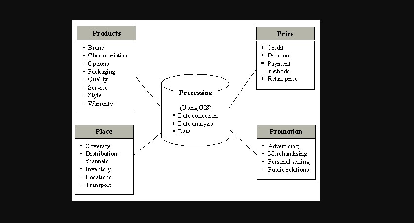
A broad variety of subjects are covered by marketing research. Beaumont (1991 ) states that the four Ps can conventionally be summarized as the marketing mix: commodity, price, location, and promotion. It implies that a fifth P-that of data processing-should be applied to these, making it possible to combine GIS and the marketing mix (Please refer to the figure below). This highlights the crucial role that GIS can play as an instrument for combining the different components of the marketing mix to help strategic decision-making.
Figure: 1 The integration of the marketing mix (‘five Ps’)[after Beaumont, 1991, P140]
These examples show the intensity of GIS in broadening the marketing perspective and can be easily shaped from an agro-marketing perspective.
WHY GIS?
GIS provides farmers with a number of important opportunities, such as improving output, reducing input costs, and more productive output management. GIS plays a crucial role, from machine mapping in the agro-field to the scientific analysis of output data at the farm level. Examples of GIS applications in the agricultural sector are given below.
Data Management
GIS provides farmers engaged in agricultural development with first-hand experience and insight into how best to handle the natural resources of a farm. Farmers need to have the best knowledge in order to make the correct decision, always in the field at the right time.
Creating Data
Through the Interpolation method, by taking many single points, an agriculturalist can create data. Such points can include crop yield data collected from a combined harvester, manually collected soil samples from a field, or information on water quality collected from watering points or wells. Interpolating these points would provide farmers with more useful details, such as crop yield maps, soil chemistry maps, and water chemical content maps (such as the degree of contamination of nitrates or arsenic) and so many others.
Agro-DSS
Any imminent application of GIS in agriculture is unique; there are, however, some essential concepts attached to it. In order to perform significant research, agricultural users have to access data relating to necessary agricultural inputs, agro-techniques, irrigation techniques, crop insurance, warehousing, and marketing logistics. Agriculture can be seen as a new arena for GIS adoption, but for more than 70 years, aerial photos and satellite imagery have been used successfully.
Analysis
In GIS, knowledge collection is fully location-specific. At the farm level, geo-referenced data can aid in better decision-making for improved supervision and productivity improvement. The important aspect is to use this knowledge judiciously to increase agro-productivity by selecting the right crop for the right fields or measuring the number of inputs needed for a season-long crop. Agriculture is being more affected than ever before by industry conferences, corporate engagement, and government regulations. In order to make such a key analysis with the aid of GIS, a farmer must now have more knowledge-driven, appropriate knowledge in such areas as farm accounting, agricultural legislation, subsidy guidelines, tax regulations, and, perhaps most importantly, crop insurance is tremendously important.
Maps & Reports
An image is often worth a thousand words, but an objective approach is given by an intelligent diagram. GIS offers such a luxury as a collection of maps and analytical reports to have all of the farm data readily accessible.
Farm Optimization
Precession Farming aims at maximizing the yield of agriculture. A farmer has to strike balance between agro-inputs and crop yields. Huge GIS adoption in agriculture has an enormous effect on the optimization of process farming, where the ultimate goal is to minimize costs.
Support Services
Farm inputs range from seed, fertilizer, and agrochemicals to machinery components, and other essential services such as crop insurance and Agro-credits. Two more basic applications where GIS can be used effectively to improve operational efficiency while on the other side providing the best possible service to the agro-consumers are;
- Insurance Claim Assessments.
- Crop risk assessments.
Supply Chain Management Based on GIS
If GIS were to be adopted by agro-businesses, the ultimate advantage would be to optimize replenishment capabilities. The approach will be to calculate current and potential demand for a service that needs delivery to a particular area. It can also mitigate losses caused by material being stored in the wrong place for too long. The life cycle of goods will be shortened by a more effective distribution network, thereby releasing asset investments and faster ROI, enhancing resource efficiency and allocation. On a real-time and place basis, it would bring an improved capacity to align disposable capital to unique distribution requirements.
#agro_research_international
Contact:
If you have any questions, thoughts, or suggestions, please contact us or join our social media networks.
Email us: agribusinessedu@gmail.com, info@agribusinessedu.com
Feel free to comment:
Your email address will not be shared with anyone.
Join our LinkedIn group
https://www.linkedin.com/groups/13943442/
Join our Facebook group
https://www.facebook.com/groups/agribusinesseducationandresearchinternational
You may read:
Agribusiness operational decision-making tools – Agribusiness Education and Research International
The Dollar Crisis and Agro Enterprise Management – Agribusiness Education and Research International
https://agribusinessedu.com/why-is-market-information-important/
Agribusiness value chain in Southeast Asia – Agribusiness Education and Research International
You May Read: What are the Characteristics and Traits of an Entrepreneur? – Agribusiness Education and Research International
You may read: Agribusiness how it works? – Agribusiness Education and Research International
You may read: Covid -19 Pandemic Impact on Agribusiness – Agribusiness Education and Research International
You may read: What is Agribusiness? – Agribusiness Education and Research International
You may read: Agribusiness in Bangladesh – A Basic Introduction – Agribusiness Education and Research International
You may read: Organic Agriculture Introduction – Agribusiness Education and Research International
You may read: What is Sustainable Agriculture? – Agribusiness Education and Research International
What is Permaculture? – Agribusiness Education and Research International
E-Commerce and Supply Chain Finance – Agribusiness Education and Research International
What is Supply Chain Finance? – Agribusiness Education and Research International
What is an agile supply chain in Agribusiness? – Agribusiness Education and Research International
What is Supply Chain Management in Agribusiness? – Agribusiness Education and Research International
Supply chain management and Agribusiness – Agribusiness Education and Research International
Factors Affecting Supply Elasticity – Agribusiness Education and Research International